
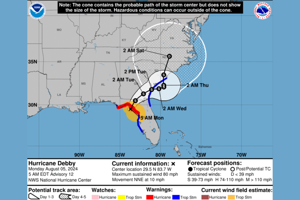
At 5:00 AM on Monday, August 5, 2024 Hurricane Debby is close to landfall in the Florida Big Bend. Not much has changed overnight for Bulloch County. We still anticipate weather conditions to deteriorate throughout the day with rain and wind increasing mid to late afternoon.
Public safety officials ask that citizens limit travel especially on dirt roads as those conditions will continue to deteriorate especially as rain begins. This will be a multi day event bringing lots of rain and wind. We do expect power outages an encourage citizens to make plans now to be without power.
Our team is monitoring the storm closely and will continue updates throughout the day and the duration of the storm.
CLICK HERE to view the 6 AM NWS Charleston Hurricane Debby briefing (Next briefing is at 11:30 AM)
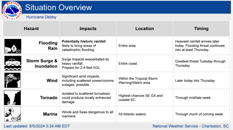
Situation Overview
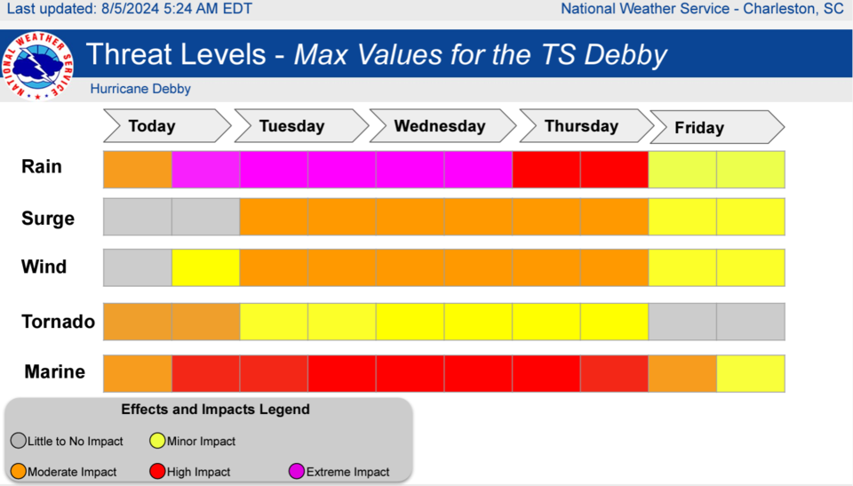
Potentially historic rainfall amounts will likely produce areas of catastrophic flooding through at least Thursday. Rainfall amounts of 10 to 20 inches, with local amounts approaching 30 inches, will bring unprecedented flooding to some areas. The highest rainfall totals will occur across coastal South Carolina and Georgia, including the Charleston and Savannah metropolitan areas. THIS IS A POTENTIALLY SIGNIFICANT AND LIFE THREATENING EVENT.
What is currently Hurricane Debbie is expected to become a tropical storm as it very slowly moves along the Southeast coast through mid- to-late week, resulting in prolonged impacts to our area. A combination of fresh water flooding and storm surge will produce coastal inundation of 2 to 4 feet along the Southeast Georgia and Southeast South Carolina coast, especially Tuesday through Thursday. Tropical storm force wind impacts and several tornadoes are also possible during this time, with highest chances across coastal areas.
Watches and advisories
- Flood Watch in effect from August 5, 2:00 AM until August 9, 8:00am
- Hazardous Weather Outlook
- Hurricane Local Statement
- Tropical Storm Watch
Key Take-Aways
- TS Debby is now Hurricane Debby and expected to make near FL Big Bend Monday morning
- Track Update: Hurricane Debby is expected to return to TS Debby and is likely to move very slowly near/over the area this week. Still a lot of uncertainty in track & intensity of storm when it reaches GA/SC.
- Rainfall Flooding: HISTORIC rainfall amounts likely. Widespread severe to catastrophic flooding/flash flooding likely.
- Combination of Heavy Rainfall & Potential Storm Surge could create catastrophic/destructive flooding in/around the tidal zone
Topical Storm Debby Potential Impacts
As of 5 am on Monday, August 5, 2024
Hurricane/TS Storm Debby is expected to produce rainfall totals of 10 to 20 inches of rainfall, with local amounts to 30 inches, are expected through Friday morning. This potentially historic rainfall will likely result in areas of severe and widespread flash and urban flooding, with significant river flooding expected.
TROPICAL STORM WATCH
Which means tropical storm-force winds are possible somewhere withing this area within the next 48 hours.
Statesboro, Portal and Denmark have the highest probability for storm-force winds
- Potential rainfall totals have increased to 10 - 20 inches, up to 30 in some areas.
- Potential for historic rainfall amounts producing widespread severe flash flooding late Sunday night through Thursday.
- Potential for wind 39 to 57 mph
- Potential for several tornadoes
- The Earliest Reasonable Time of Arrival of Tropical Storm Force Winds: GA - Monday morning, into the afternoon
- Most Likely Time this area could see Tropical Storm Force Winds: GA - Monday night
- Bulloch County residents who live on the river and in areas that are prone to flood need to make a plan now plan to move to safe shelter on higher ground.
- Bulloch County citizens who live on dirt roads need to prepare for challenging road conditions. Please limit dirt road travel as much as possible over the next few days.
Closings
Click Here for closings.
FLOOD WATCH REMAINS IN EFFECT FROM LATE TONIGHT THROUGH FRIDAY MORNING
Flash flooding caused by excessive rainfall continues to be possible.
WHERE...Portions of southeast Georgia, including the following areas, Bulloch, Candler, Coastal Bryan, Coastal Chatham, Coastal Liberty, Coastal McIntosh, Effingham, Evans, Inland Bryan, Inland Chatham, Inland Liberty, Inland McIntosh, Jenkins, Long, Screven and Tattnall and southeast South Carolina, including the following areas, Allendale, Beaufort, Charleston, Coastal Colleton, Coastal Jasper, Dorchester, Hampton, Inland Berkeley, Inland Colleton, Inland Jasper and Tidal Berkeley.
WHEN...From 2 am Monday through Friday morning
IMPACTS...Potentially historic rainfall amounts will likely result in severe widespread flash flooding.
ADDITIONAL DETAILS... Tropical Storm Debby is expected to stall near the area mid to late week. Widespread rainfall amounts of 10 to 20 inches, with local amounts toward 30 inches are expected. - http://www.weather.gov/safety/flood
You should monitor later forecasts and be prepared to take action should Flash Flood Warnings be issued. Be prepared to protect life and property, especially in areas prone to flooding. If flooding develops, move to higher ground immediately. If driving, be prepared for flooded roadways and possible road closures.
Key Websites
Here are a few key websites that will may be helpful to you as the storm progresses:
Grice Connect FB Page (we update rapidly changing weather conditions quickly on our Facebook page. Make sure to like and follow)
Georgia Power (GPC) Outage Map
Excelsior EMC (EMC) Outage Map
To request assistance for non-emergency incidents, like a tree or water covering the roadway PLEASE DO NOT CALL 911. 911 should be reserved for life or death emergencies especially in potential high call volume incidents.
Statesboro Police Department Non-Emergency number -912-764-9911
Bulloch County Sheriffs Office Non-Emergency number - 912-764-8888
State of Emergency
Governor Kemp has declared a State of Emergency in all 159 counties of Georgia due to the potential negative impacts of Tropical Depression 4.
This order makes all resources of the State of Georgia available to assist in preparation, response, and recovery activities throughout affected areas and directs activation of the Georgia Emergency Operations Plan (GEOP).
See Executive Order 08.03.24.01
Bulloch EMA remains in Increase Readiness phase.
Make a plan
Director Kemp encourages citizens to take proactive steps now that will help navigate the impact of storms that arise next week.
While it's too early to predict exactly where and when it will arrive, it is essential for us all to be prepared. Whether it's your family or your business, the presence of this storm is an active reminder to thoroughly review and update your emergency plan:
- print a copy to ensure it is available during a loss of power
- verify and update contact information
- do you have emergency supplies of food, water, and fuel?
Remember generator safety if there is a loss of power. Inspect your property limbs, chairs, and trampolines. They can become flying projectiles.
Monitor weather updates such as the National Hurricane Center and National Weather Service CHS, Grice Connect or the local media of your choice.
Code Red Alert
The City of Statesboro and Bulloch County announced a partnership to implement the CodeRED system, a high-speed emergency notification service provided by OnSolve, based in Ormond Beach, Florida. Public safety officials across the United States have credited CodeRED notifications for saving lives, including locating missing children, apprehending wanted criminals, and issuing timely evacuations.
Click here to add this to your phone now.
Be Alert
Be ready to take action should severe weather develop. Stay tuned to NOAA Weather Radio, Grice Connect, Bulloch County EMA, TV or your local news source for the latest information from the National Weather Service.
Click here for updated weather information throughout the day.
The Grice Connect team will continue to monitor this storm through the weekend.


