
Ted Wynn, Bulloch County public safety/EMA/HS director provides an update on Nov. 10 for Tropical Storm Nicole from Will Lanxton, meteorologist for GEMA/HS.
Thursday through Friday NWS Hazardous Weather Outlook for Bulloch
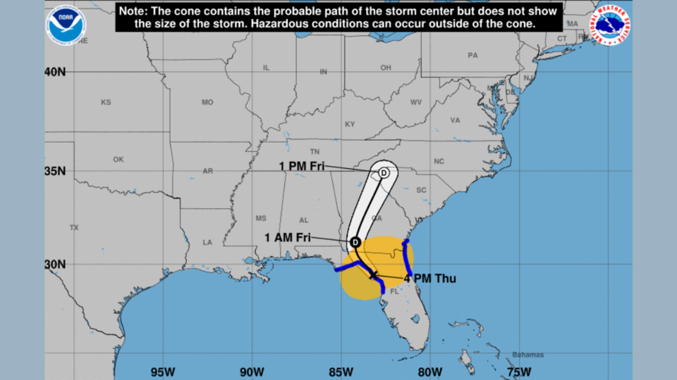
Thursday, Nov. 10
Heavy Rain: There is the risk for heavy rain and possible flooding across parts of the area. Flood Advisories could be needed.
Severe Thunderstorms: Isolated severe thunderstorms are possible, the main hazard being an isolated brief tornado.
Friday, Nov. 11
There is a low probability for widespread hazardous weather.
Updates since yesterday
Nicole made landfall around 3 a.m. as a low-end Category 1 hurricane. Maximum sustained winds are estimated at 75 mph on North Hutchinson Island just south of Vero Beach on the east coast of the Florida peninsula.
At the time of this report the storm was centered near Tampa. Estimated maximum winds are 50 mph moving to the west-northwest at 16 mph.
The storm will continue to gradually weaken as it turns to the north and crosses into southern Georgia tonight. It could still be at tropical storm strength when the center moves into Georgia, but it is forecast to weaken to a tropical depression by Friday morning.
What remains of Nicole will turn northeastward on Friday and exit eastern Georgia by Friday evening. Conditions will gradually improve from south to north tomorrow afternoon and evening, and much colder weather will move in this weekend.
Watches, warnings and advisories
- A Storm Surge Warning remains in effect for Camden and Glynn Counties.
- A Storm Surge Watch is still in effect for the remainder of the Georgia coast.
- A Tropical Storm Warning is in effect for all coastal Georgia counties. Additionally, a Tropical Storm Warning has been issued for all of South Georgia, including all Georgia counties within the National Weather Service Jacksonville and Tallahassee areas of responsibility.
- A Tornado Watch is in effect for Camden and Glynn Counties through 1 p.m. Additional Watches will likely be issued throughout the event, especially in Southeast Georgia.
- A Wind Advisory has been issued for much of North and Central Georgia. Parts of Central Georgia north of the Tropical Storm Warning (Warner Robins, Dublin, Americus, Cordele, and Vidalia areas) are under a High Wind Warning for gusts up to 45 mph.
Inland impacts
Outer rain bands have already begun to move into southern and southeastern Georgia and will continue to overspread the rest of Georgia from south to north throughout today and tonight.
Winds will continue to increase throughout the afternoon and evening as well, with gusts of 30 to 40 mph expected statewide and up to 50 mph possible in southern Georgia. Heavy rainfall will be possible, accumulating to one to three inches across the state.
Southern Georgia should see the highest rainfall amounts, but with the system moving through so quickly today and tomorrow, widespread flooding is not anticipated.
Localized flooding is possible where fallen leaves clog storm drains. A few tornadoes are also possible today through tomorrow morning, especially in southeastern Georgia.
Coastal impacts
Dangerous coastal conditions will continue today through tomorrow morning for the entire Georgia coast, including coastal flooding, significant beach erosion, dangerous sea and surf conditions, and life-threatening rip currents. Three-to-five-feet storm surge inundation will be possible in Camden and Glynn Counties, with two-to-four feet possible in McIntosh, Liberty, Bryan, and Chatham Counties.
These inundation levels will be most pronounced if they coincide with the astronomical high tides this evening and tomorrow morning. Tropical storm force sustained winds with higher gusts could cause damage to trees, power lines, and structures. The tornado threat will also be highest in the coastal counties through tomorrow morning.
Please continue to monitor forecast updates from the National Hurricane Center.


