
On Tuesday, August 29, 2023 Bulloch County Public Safety Director Ted Wynn asks Bulloch County Citizens to make final preparations for Idalia.
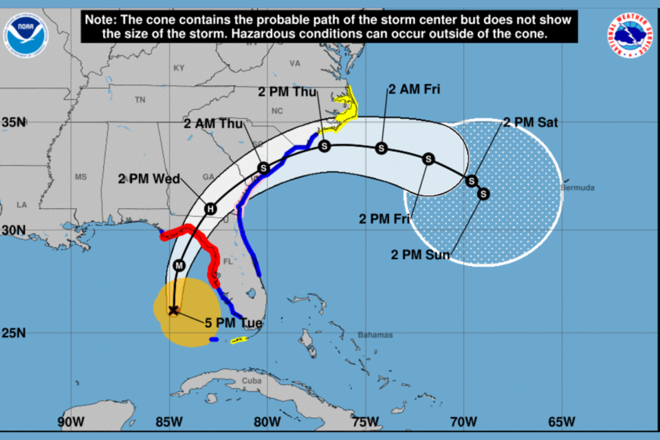
Cat 2 hurricane Idalia with 100 MPH winds is tracking north in the Gulf at 16 mph. It is expected to make landfall tomorrow morning in the Big Bend of Florida as a major hurricane.
It will weaken after making landfall to a Cat 1 hurricane with 85 MPH winds into south Georgia.
Bulloch will remain under a tropical storm warning, so we expect strong winds and heavy bands of rain starting late morning tomorrow and continuing into Thursday morning. The NHC latest projection is above.
Confidence is growing in the forecast so make final preps now.
What has changed for Bulloch and surrounding counties since Tuesday morning:
Currently we are under a tropical storm warning. Our rainfall forecast has remains at (4-8) inches possible with local flash flooding possible as forecasters predict most of Idalia’s rainfall will be to the NW side of the track.
We strongly advise you to finalize your plans.
Check your disaster supplies kit, make a plan, and stay informed.
Bulloch Schools, GS and OTC have closed their campuses on Wednesday.
CLICK HERE to review all closing.
NWS Charleston updates
Hurricane Idalia continues to track northward across the eastern Gulf of Mexico while strengthening. Idalia is still forecast to make landfall as a major hurricane in the Big Bend region of Florida Wednesday morning. After making landfall, Idalia is forecast to track just inland through southeast Georgia and southeast South Carolina Wednesday evening through early Thursday morning.
Local impacts from Idalia will begin as early as Wednesday morning as heavy rainfall begins to overspread southeast Georgia and southeast South Carolina from southwest to northeast. Heavy rainfall is expected to continue through Wednesday night across the region with 1 to 3 inches of rain forecast along the coast and 4 to 8 inches forecast for inland locations. Tropical Storm force winds are expected to develop across southeast Georgia late Wednesday morning, especially along the coast, with conditions deteriorating Wednesday afternoon and into Wednesday night as Tropical Storm force winds spread up the coast and into portions of southeast South Carolina. Tornadoes will be possible across the area Wednesday afternoon and Wednesday night, particularly along the coast, and waterspouts will be possible across the adjacent Atlantic coastal waters. Finally, there is the potential for storm surge Wednesday evening through early Thursday morning along the southeast Georgia and southeast South Carolina coasts, where inundation up to 4 feet above ground level is possible.
TIMING
- Tropical Storm force winds are expected to develop across southeast Georgia late Wednesday morning, especially along the coast, with conditions deteriorating Wednesday afternoon and into Wednesday night as Tropical Storm force winds spread up the coast and into portions of southeast South Carolina.
HAZARDS & IMPACTS
- Some damage to roofing and siding materials, along with damage to porches, awnings, carports, and sheds. A few buildings experiencing window, door, and garage door failures. Mobile homes damaged, especially if unanchored.
- Unsecured lightweight objects become dangerous projectiles.
- Several large trees snapped or uprooted, but with greater numbers in places where trees are shallow rooted.
- Some roads impassable from large debris, and more within urban or heavily wooded places. A few bridges and access routes impassable.
- Travel by vehicle or on foot increasingly difficult. Danger of death or injury from falling objects such as trees or electric wires outside.
- Scattered power and communications outages, but more prevalent in areas with above ground lines, which could persist for hours or days.
- Some poorly secured small craft could break loose from their moorings.
Statesboro Forecast
As of 5 PM, Tuesday, August 29, 2023
CLICK HERE for updated forecast.
Tuesday Night
Showers and thunderstorms likely, mainly before 8pm. Mostly cloudy, with a low around 74. Southeast wind 5 to 8 mph becoming calm after midnight. Chance of precipitation is 70%. New rainfall amounts between a tenth and quarter of an inch, except higher amounts possible in thunderstorms.
Wednesday
Tropical storm conditions possible. A chance of showers and thunderstorms, then showers and possibly a thunderstorm after 9am. Some of the storms could produce heavy rainfall. High near 80. Chance of precipitation is 100%. New rainfall amounts between 2 and 3 inches possible.
Wednesday Night
Tropical storm conditions possible. Showers and possibly a thunderstorm, mainly before 2am, then a chance of showers and thunderstorms after 2am. Some of the storms could produce heavy rainfall. Low around 71. Chance of precipitation is 100%. New rainfall amounts between 1 and 2 inches possible.
Thursday
A chance of showers, with thunderstorms also possible after 2pm. Partly sunny, with a high near 83. North wind 10 to 15 mph, with gusts as high as 24 mph. Chance of precipitation is 30%.
Thursday Night
Partly cloudy, with a low around 64. Northeast wind around 6 mph.
Friday
Sunny, with a high near 82.
Prepare now
- For potential widespread power outages
- Dirt roads that may become difficult to navigate
- Have a few days of supplies including food and water Tips for an emergency kit
- If you live in unstable housing prepare to go to friends or relatives home to ride out the storm
- If you have a home oxygen generator or other medical devices that need power, make a plan to go to a relative or friends home who may have power or a generator
- If you live on a dirt road that you must take into consideration the impact a large amount of rain coming very quickly will have on the roads.
Grice Connect is committed to being here for you providing you the important news you need, when you need it.
We are monitoring the storm and will keep you updated as Idalia progresses.
Now is the time to be thinking about your Hurricane preparation plans which include liking and following Grice Connect on Facebook and subscribing to Grice Connect daily emails so you can keep up with how this storm could impact Statesboro and Bulloch County.

For more hyper-local Statesboro, Georgia Southern, and Bulloch County news and events delivered directly to your inbox every day, subscribe to Grice Connect's Bulloch Daily email by clicking here. Totally FREE and ALL LOCAL! Unsubscribe at anytime.


