
On Monday, August 28, 2023 Bulloch County Public Safety Director Ted Wynn asks Bulloch County Citizens to make final preparations for Idalia today.
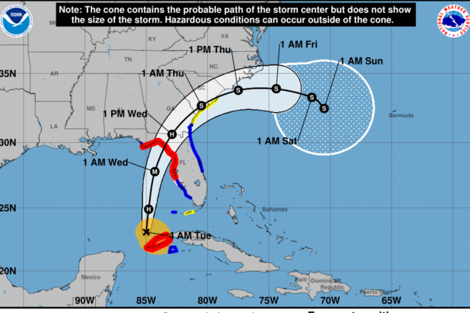
Idalia is a hurricane and on the move. Currently Idalia has moved into the Gulf of Mexico and headed for somewhere in the big bend of Florida as a major hurricane early Wednesday morning.
Located in the southern gulf Idalia has maximum sustained winds of 75 mph and is moving north at 14 mph.
What has changed for Bulloch and surrounding counties since Monday:
Currently we are under a tropical storm watch. Also, our rainfall forecast has increased. (4-8) inches are possible with local flash flooding possible as forecasters predict most of Idalia’s rainfall will be to the NW side of the track.
We strongly advise you to finalize your plans today.
Check your disaster supplies kit, make a plan, and stay informed.
Emergency officials will be meeting today in the Emergency Operations Center to finalize preparations for response.
Bulloch Schools should be deciding today about any closings. Their website will have information on that. Stay safe!
TIMING
- The greatest impacts for southeast Georgia and southeast South Carolina are expected to occur late Wednesday morning through early Thursday morning.
HAZARDS & IMPACTS
- Details regarding the track, intensity, and timing of Idalia are still being refined. However, confidence in the following impacts is increasing: ▪ Heavy rainfall: 4-8 inches of rain possible across SE GA/SC.
- Strong, gusty winds: The probability of tropical storm force winds remains moderate to high, especially along the coast. Hurricane conditions remain possible across portions of the GA Atlantic waters.
- Storm surge/coastal flooding: based on the timing of the current forecast track, the Wednesday evening (~8:30 PM) high tide cycle could produce the highest water levels.
- Rip currents, high surf, and possibly significant beach erosion.
- Risk for tornadoes across the coastal counties of SE GA/SC Wed. and Wed. night. NWS ALERTS
- A Tropical Storm Watch has been issued for portions SE GA/SC through Thursday morning.
- A Storm Surge Watch has been issued for the SE GA/SC coast through Thursday morning
Statesboro Forecast
As of 5 AM, Tuesday, August 29, 2023
CLICK HERE for updated forecast.
Tuesday
Showers and thunderstorms likely, mainly after 3pm. Partly sunny, with a high near 90. Heat index values as high as 101. Calm wind becoming southeast 5 to 9 mph in the morning. Chance of precipitation is 60%. New rainfall amounts between a quarter and half of an inch possible.
Tuesday Night
Showers and thunderstorms likely, mainly after 4am. Mostly cloudy, with a low around 74. South wind 3 to 7 mph. Chance of precipitation is 60%. New rainfall amounts between a quarter and half of an inch possible.
Wednesday
Tropical storm conditions possible. Showers likely and possibly a thunderstorm, then showers and thunderstorms after 8am. Some of the storms could produce heavy rainfall. High near 79. Chance of precipitation is 90%. New rainfall amounts between 3 and 4 inches possible.
Wednesday Night
Tropical storm conditions possible. Showers and thunderstorms likely, mainly before 2am. Mostly cloudy, with a low around 69. Chance of precipitation is 70%. New rainfall amounts between 1 and 2 inches possible.
Thursday
A 30 percent chance of showers and thunderstorms. Partly sunny, with a high near 81. Northwest wind 5 to 9 mph.
Thursday Night
Mostly clear, with a low around 64.
Friday
Sunny, with a high near 82.
Friday Night
Mostly clear, with a low around 62.
Prepare now
- For potential widespread power outages
- Dirt roads that may become difficult to navigate
- Have a few days of supplies including food and water Tips for an emergency kit
- If you live in unstable housing prepare to go to friends or relatives home to ride out the storm
- If you have a home oxygen generator or other medical devices that need power, make a plan to go to a relative or friends home who may have power or a generator
- If you live on a dirt road that you must take into consideration the impact a large amount of rain coming very quickly will have on the roads.
Grice Connect is committed to being here for you providing you the important news you need, when you need it.
We are monitoring the storm and will keep you updated as Idalia progresses.
Now is the time to be thinking about your Hurricane preparation plans which include liking and following Grice Connect on Facebook and subscribing to Grice Connect daily emails so you can keep up with how this storm could impact Statesboro and Bulloch County.

For more hyper-local Statesboro, Georgia Southern, and Bulloch County news and events delivered directly to your inbox every day, subscribe to Grice Connect's Bulloch Daily email by clicking here. Totally FREE and ALL LOCAL! Unsubscribe at anytime.


