
Bulloch County Public Safety Director Ted Wynn continues to monitor Tropical Storm Idalia on Monday, August 28, 2023.
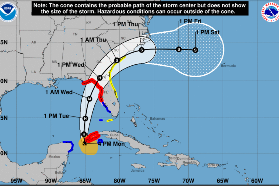
The 5 pm update from the NHC shows that Idalia has slowed slightly pushing effects on us into Wednesday afternoon well into Wednesday night.
If you look at the previous updates, you will be able to observe this. Currently Idalia is moving north at 8 mph and has maximum sustained winds at 70 mph.
Impacts forecasted for us have not changed significantly except we are now in a higher probability of some TS force winds impacting us Wednesday morning into Wednesday night. This could change overnight so stay informed on Idalia. Above is the latest images from the NHC.
Local Impact
- Heavy rain of 4-8 inches is possible.
- Sustained tropical storm force winds of 40 to 50 mph will begin to be felt across the southeast Georgia coast on Wednesday morning.
- Tornadoes will be possible across the area Wednesday afternoon and Wednesday night.
- Expect scattered power outages.
Statesboro Forecast
As of 5 PM, Monday, August 28, 2023
CLICK HERE for updated forecast.
Monday Night
A 30 percent chance of showers and thunderstorms, mainly before 7pm. Partly cloudy, with a low around 73. Southeast wind around 6 mph becoming calm in the evening.
Tuesday
Showers and thunderstorms likely, mainly after 2pm. Partly sunny, with a high near 90. Calm wind becoming southeast 5 to 8 mph in the morning. Chance of precipitation is 60%. New rainfall amounts between a tenth and quarter of an inch, except higher amounts possible in thunderstorms.
Tuesday Night
Showers and thunderstorms likely, mainly after 3am. Mostly cloudy, with a low around 72. Southeast wind 5 to 7 mph. Chance of precipitation is 60%. New rainfall amounts between a quarter and half of an inch possible.
Wednesday
Tropical storm conditions possible. Showers and thunderstorms. Some of the storms could produce heavy rainfall. High near 79. Chance of precipitation is 90%. New rainfall amounts between 3 and 4 inches possible.
Wednesday Night
Tropical storm conditions possible. Showers and thunderstorms likely, mainly before 2am. Mostly cloudy, with a low around 69. Chance of precipitation is 70%. New rainfall amounts between 1 and 2 inches possible.
Thursday
A 30 percent chance of showers and thunderstorms. Partly sunny, with a high near 81.
Thursday Night
Mostly clear, with a low around 64.
Friday
Sunny, with a high near 82.
Friday Night
Mostly clear, with a low around 62.
NWS Charleston Update
Tropical Storm Idalia is expected to track into the southeast Gulf of Mexico while strengthening to Hurricane intensity this evening. Further strengthening is possible as Idalia moves north-northeastward toward the Florida Big Bend on Tuesday and Tuesday night, making landfall as a major Hurricane Wednesday morning. Idalia will then turn northeastward and accelerate across southeast Georgia and southeast South Carolina Wednesday afternoon through Wednesday night.
Local impacts from Idalia will begin Wednesday morning as heavy rainfall begins to overspread southeast Georgia and southeast South Carolina from southwest to northeast. Heavy rainfall will then continue through Wednesday night across the region with 4 to 8 inches of rainfall forecast. Sustained tropical storm force winds of 40 to 50 mph will begin to be felt across the southeast Georgia coast on Wednesday morning with conditions deteriorating Wednesday afternoon
where occasional hurricane force wind gusts are possible along the southeast Georgia coast.
Sustained tropical storm force winds will develop along the southeast South Carolina coast Wednesday afternoon and persist through Wednesday night. Tornadoes will be possible across the area Wednesday afternoon and Wednesday night, particularly along the coast and waterspouts across the coastal waters. Finally, there is the potential for storm surge Wednesday afternoon through Wednesday night along the southeast Georgia and southeast South Carolina coasts, where inundation up to 4 feet above ground level is possible.
Prepare now
Grice Connect is committed to being here for you providing you the important news you need, when you need it.
We are monitoring the storm and will keep you updated as Idalia progresses.
Now is the time to be thinking about your Hurricane preparation plans which include liking and following Grice Connect on Facebook and subscribing to Grice Connect daily emails so you can keep up with how this storm could impact Statesboro and Bulloch County.

For more hyper-local Statesboro, Georgia Southern, and Bulloch County news and events delivered directly to your inbox every day, subscribe to Grice Connect's Bulloch Daily email by clicking here. Totally FREE and ALL LOCAL! Unsubscribe at anytime.


