
Bulloch County Public Safety Director Ted Wynn continues to monitor Tropical Storm Idalia on Monday, August 28, 2023.
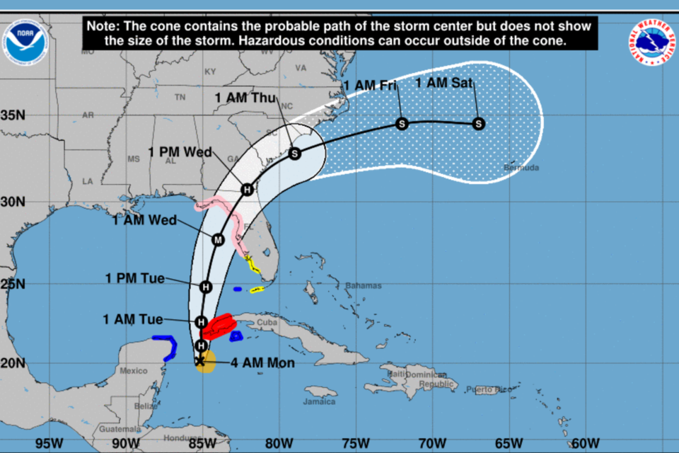
TS Idalia is expected to intensify into a hurricane today and move northward towards the Florida coast. On its current project path and forecast Idalia could impact south Georgia as a Cat 1 storm early Wednesday morning. The images above are from the 5am forecast from the NHC.
Public Safety and Bulloch Emergency Management crews have already begun preparations for effects expected from Idalia. We can expect the most impacts from Idalia on Wednesday morning into Wednesday night. Get prepared now and stay informed on Tropical storm Idalia soon to be hurricane Idalia.
Local Impact
- Heavy rain of 4-8 inches is possible.
- Strong gusty winds and the possibility of TS force winds is increasing.
- Tornado threat is possible Wednesday morning as the system approaches our area.
- Scattered power outages will be possible.
Statesboro Forecast
As of 5 AM, Monday, August 28, 2023
CLICK HERE for updated forecast.
Monday
A 30 percent chance of showers and thunderstorms, mainly after 5pm. Partly sunny, with a high near 93. Heat index values as high as 102. Calm wind becoming east 5 to 8 mph in the afternoon.
Monday Night
A 30 percent chance of showers and thunderstorms, mainly before 7pm. Mostly cloudy, with a low around 74. Southeast wind 3 to 8 mph.
Tuesday
Showers and thunderstorms likely, mainly after 3pm. Partly sunny, with a high near 91. Calm wind becoming southeast 5 to 8 mph in the morning. Chance of precipitation is 60%. New rainfall amounts of less than a tenth of an inch, except higher amounts possible in thunderstorms.
Tuesday Night
Showers and thunderstorms likely. Mostly cloudy, with a low around 72. Southeast wind 5 to 8 mph. Chance of precipitation is 70%. New rainfall amounts between a quarter and half of an inch possible.
Wednesday
Tropical storm conditions possible. Showers and possibly a thunderstorm. Some of the storms could produce heavy rainfall. High near 80. Chance of precipitation is 90%. New rainfall amounts between 2 and 3 inches possible.
Wednesday Night
A 50 percent chance of showers and thunderstorms, mainly before 2am. Mostly cloudy, with a low around 69. Breezy. New rainfall amounts between three quarters and one inch possible.
Thursday
A 30 percent chance of showers and thunderstorms, mainly after 2pm. Mostly sunny, with a high near 83.
Thursday Night
A 30 percent chance of showers and thunderstorms, mainly before 8pm. Mostly clear, with a low around 65.
Friday
A 20 percent chance of showers and thunderstorms after 2pm. Sunny, with a high near 83.
Friday Night
Mostly clear, with a low around 63.
National Hurricane Center Update
The NHC 5 am update Idalia is now forecast to become a major hurricane before it reaches the Gulf coast of Florida. The risk continues to increase for life-threatening storm surge and dangerous hurricane-force winds along portions of the west coast of Florida and the Florida Panhandle beginning as early as late Tuesday. Storm surge and hurricane watches are in effect for portions of the west coast of Florida and the coast of the Florida Panhandle, and residents in these areas should monitor updates to the forecast and follow any advice given by local officials.
Areas of flash and urban flooding, some of which may be locally significant, are expected across portions of the west coast of Florida, the Florida Panhandle, and southern Georgia Tuesday into Wednesday, spreading into portions of the eastern Carolina's Wednesday into Thursday.
Note: The cone contains the probable path of the storm center but does not show the size of the storm. Hazardous conditions can occur outside of the cone.
Prepare now
Grice Connect is committed to being here for you providing you the important news you need, when you need it.
We are monitoring the storm and will keep you updated as Idalia progresses.
Now is the time to be thinking about your Hurricane preparation plans which include liking and following Grice Connect on Facebook and subscribing to Grice Connect daily emails so you can keep up with how this storm could impact Statesboro and Bulloch County.

For more hyper-local Statesboro, Georgia Southern, and Bulloch County news and events delivered directly to your inbox every day, subscribe to Grice Connect's Bulloch Daily email by clicking here. Totally FREE and ALL LOCAL! Unsubscribe at anytime.


