
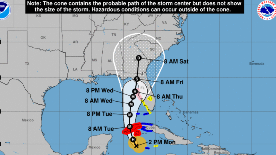
Hurricane Ian is located west of Grand Cayman and south of western Cuba with 80 mph (Category 1) maximum sustained winds. It is moving to the northwest at 13 mph and will undergo rapid intensification today and tomorrow before topping out as a Category 4 hurricane on Wednesday in the southeastern Gulf of Mexico.
As Ian approaches the western side of the Florida Panhandle on Wednesday and Thursday, increasing wind shear and dry air intrusion will begin a weakening trend before it makes landfall. The forward motion of the system will also slow down dramatically, and Ian could meander in the northeastern Gulf of Mexico on Thursday before picking up steam to the north again on Friday, likely as a Category 1 hurricane or tropical storm. However, there is still a high level of uncertainty in the 3- to 5-day track forecast. Ian is expected to continue weakening on Friday and Saturday as it moves inland.
A strong onshore flow is expected to bring significant impacts to coastal areas of Georgia late Wednesday into Thursday even though Ian will be west of Central Florida. Tropical storm force conditions will be possible along the immediate coastline and offshore on Wednesday and Thursday, with coastal flooding, dangerous rip currents, high surf, and beach erosion all possible. These threats will begin with high tides on Wednesday and could reach moderate coastal flood levels on Thursday and Friday.
The outer bands of Ian could begin to move into southern Georgia on Friday morning. Bands of heavy rainfall and gusty winds potentially reaching tropical storm force will overspread Georgia from south to north on Friday and continue through Saturday.
The extent of impacts across Georgia is still uncertain and will depend on the exact track that Ian takes later in the week. In general, 4 to 6 inches of rainfall will be possible across southern Georgia with up to 8 inches in spots, particularly in Southeast Georgia. Rainfall of 3-5 inches will be possible in North and Central Georgia on Friday and Saturday. Tropical storm force winds are likely in southern Georgia but will be possible statewide as the system moves through. Ian could move out of northern and eastern Georgia as soon as Sunday morning.
With forecast uncertainty still high, please continue to monitor forecast updates from the National Hurricane Center, your local National Weather Service office, and FRice Connect and other reliable local media outlets throughout the week.
Live updates from the National Hurricane Center
Follow and Subscribe to Grice Connect Now
Now is the time to be thinking about your Hurricane preparation plans which include liking and following Grice Connect on Facebook and subscribing to Grice Connect daily emails so you can keep up with how this storm could impact Statesboro and Bulloch County.

For more hyper-local Statesboro, Georgia Southern, and Bulloch County news and events delivered directly to your inbox every day, subscribe to Grice Connect's Bulloch Daily email by clicking here. Totally FREE and ALL LOCAL! Unsubscribe at anytime.


