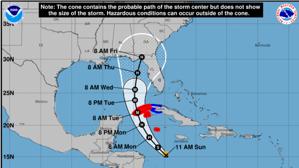
As of Sunday morning, September 25, 2022, Tropical Storm Ian was located southwest of Jamaica and is moving to the west-northwest at 14 mph with maximum sustained winds of 50 mph.
Ian is expected to begin rapidly strengthening Sunday and will undergo rapid intensification Monday and Tuesday. Ian is forecast to reach Category 4 status on Tuesday in the southeastern Gulf of Mexico, but as it moves into the northern half of the Gulf on Wednesday, it will begin to weaken.
There is still disagreement in the models on the track after 72 hours, with some showing a landfall along the Florida Panhandle and others showing a landfall along the western Florida Peninsula. The National Hurricane Center forecast splits the difference with Ian approaching the Florida Big Bend as a Category 2 hurricane on Thursday. There is still a significant amount of uncertainty on the eventual track later in the week, which will have direct implications on the extent of impacts in Georgia.
Although Ian will be weakening as it approaches the Gulf Coast late this week, the wind field will be expanding and the storm’s forward motion will be slowing. This could produce significant wind and rainfall impacts across Georgia on Friday and over the weekend, but the extent of these impacts is still unclear.
Please continue to monitor the forecast from the National Hurricane Center, Grice Connect, your local National Weather Service office, and other reliable media outlets.
Live updates from National Hurricane Center
Follow and Subscribe to Grice Connect Now
Now is the time to be thinking about your Hurricane preparation plans which include liking and following Grice Connect on Facebook and subscribing to Grice Connect daily emails so you can keep up with how this storm could impact Statesboro and Bulloch County.