
9:47 AM UPDATE: STRONG THUNDERSTORMS WILL IMPACT PORTIONS OF SCREVEN, EVANS, BULLOCH, JENKINS, CANDLER AND TATTNALL COUNTIES
Special Weather Statement issued January 4 at 9:47AM EST by NWS Charleston SC At 9:47 AM EST, National Weather Service doppler radar indicated strong thunderstorms along a line extending from 6 miles north of Herndon to near Alamo, and moving east at 45 mph.
HAZARD...strong winds 45 to 55 mph.
SOURCE...Radar Indicated.
IMPACT...Expect minor damage to tree limbs and blowing around of light, unsecured objects.
Some locations in the path of these storms include...
Statesboro, Reidsville, Metter, Millen, Sylvania, Butts, Portal and Collins.
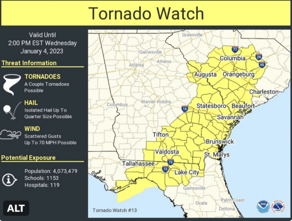
A tornado watch is in effect. Thunderstorms can produce tornadoes suddenly, sometimes with little or no warning. Be alert for rapidly changing weather conditions and be ready to act quickly if severe weather is observed or a warning is issued.
Tornado Watch
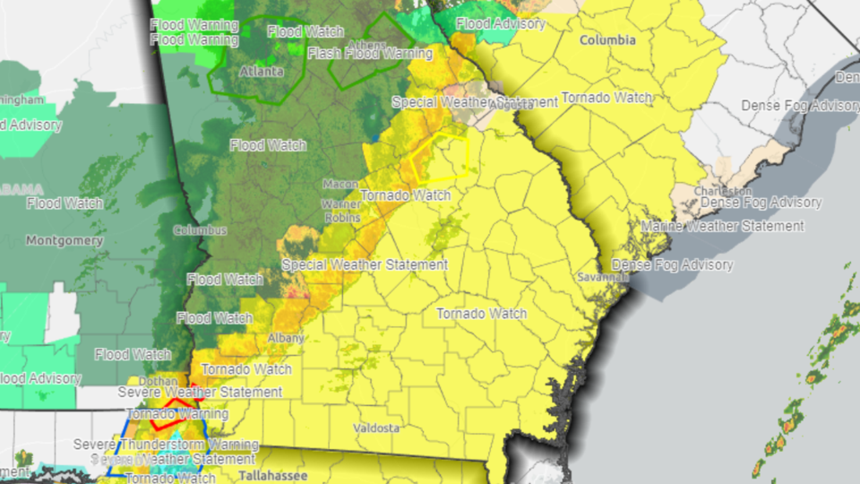
At 8:36 AM on Wednesday, January 4, 2023 NWS Charleston issued a tornado watch for Southeast Georgia including Statesboro and Bulloch County until 2 PM. Grice Connect is monitoring this rapidly changing weather situation and will keep you updated if conditions change and additional alerts are issued.
Follow Grice Connect on Facebook and Twitter for more rapid updates if conditions change quickly.
Severe Weather Alert Day
Ted Wynn, Director of Bulloch County Public Safety issued a Weather Alert Wednesday morning for citizens of Statesboro and Bulloch for Wednesday, January 4, 2023.
The NWS storm prediction center is forecasting the possibility of some severe weather for Wednesday afternoon into early evening. Below is their information. Stay alert today.
NWS/Charleston-For Wednesday, January 4, the Storm Prediction Center has issued a Slight Risk for severe thunderstorms across far inland sections of southeast Georgia, and a Marginal Risk for severe thunderstorms across the rest of southeast counties of Georgia and South Carolina.
Wednesday afternoon into early evening, a couple of thunderstorms could produce damaging wind gusts. Also, an isolated, brief tornado cannot be ruled out.
Also, thunderstorms could produce locally heavy rainfall west of Interstate 95. Farther east, excessive rainfall is unlikely.


