
On Wednesday, August 30, 2023 Bulloch County is bracing for what could be one of the most powerful storms to hit our area since Matthew or Irma.
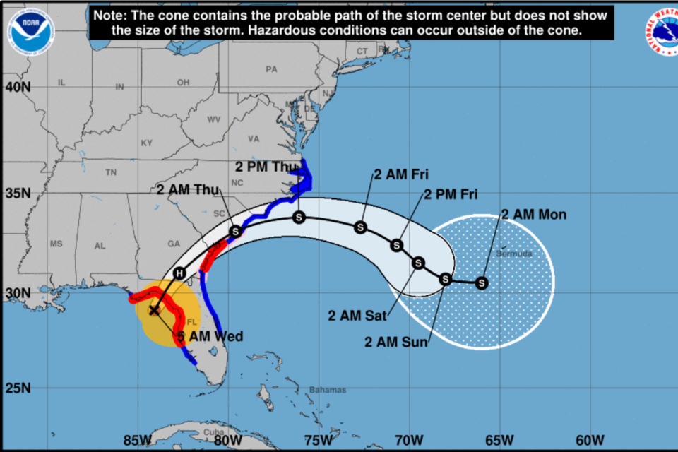
At 5 am on Wednesday Hurricane Idalia is a Cat 4 Hurricane and expected to make landfall in Florida in the next few hours. We are anticipating Tropical Storm Force Winds beginning Wednesday morning.
The greatest impacts for southeast Georgia and southeast South Carolina are expected to occur late Wednesday morning through early Thursday morning.
Bulloch County Current Alerts from NWS Charleston
- Hazardous Weather Outlook
- Hurricane Local Statement
- Flood Watch in effect from August 30, 08:00 AM EDT until August 31, 02:00 AM EDT
- Tropical Storm Warning
- Hurricane Watch
- Tornado Watch in effect from August 30, 05:35 AM EDT until August 30, 03:00 PM EDT
States of Emergency
Governor Brian P. Kemp today issued a State of Emergency order for all of Georgia on Tuesday in preparation for Hurricane Idalia's anticipated impact later this week.
Bulloch County Commission Chairman Roy Thompson, followed the Governors State of Emergency by signing a Bulloch County State of Emergency. This covers the entire county. Mayor McCollar signed a State of Emergency for the City of Statesboro on Wednesday.
A state of emergency authorizes City, County and State officials to execute emergency management plans and respond to impacts caused by Hurricane Idalia.
Shelters
Bulloch County VOAD and local churches and agencies like the Red Cross are monitoring possible shelter needs. At this time Bulloch County nor any of the counties surrounding Bulloch are planning to open emergency shelters prior to the storm at this time. If citizens are concerned about being in an unstable structure they encourage them to work to find family members, church members or friends who will allow them to ride out the storm with them. Local hotels also have availability.
From Ted Wynn, Bulloch County Public Safety Director
Very dangerous Cat 4 Idalia will make landfall in the Big Bend of Florida in the next few hours. Currently it is tracking NNE at 18 MPH with 130 MPH maximum sustained winds.
The 5 AM forecast brings Iidalia very close to Bulloch and places us under a hurricane watch. This is a change from earlier.
Idalia could still shift its track slightly and effects could vary across the county. It will move quickly to the NE.
Expect strong TS winds (Hurricane force are possible under the current forecast) with rainfall between 4-8 inches.
Starting about mid-day today if you have no reason to be out, please stay off the roads and allow our crews to focus on response to situations requiring debris clearing and emergency response.
Public Safety and Law enforcement will be fully staffed and prepared to respond, but if conditions get dangerous, we will pause response to protect them.
Stay safe and things will improve as Thursday morning approaches.
Bulloch County Public Safety Director Ted Wynn asks Bulloch County Citizens to prepare now to ride out Hurricane Idalia. Starting mid day Do not travel unless absolutely necessary especially on dirt roads.
Charge your electronic devices and prepare for widespread power outages.
Closings/Postponements/Cancelations
CLICK HERE to review all closing, postponements and cancelations.
TIMING
The greatest impacts for southeast Georgia and southeast South Carolina are expected to occur late Wednesday morning through early Thursday morning.
HAZARDS & IMPACTS
Details regarding the track, intensity, and timing of Idalia are still being adjusted. However, confidence in the following impacts is increasing
Heavy rainfall and flash flooding: Rainfall totals are forecast to range between 4 to 8 inches inland GA/SC, and 1 to 3 inches closer to the coast
Strong, gusty winds: There is a high probability of tropical storm force winds across southeast GA and SC. Hurricane force winds are possible across portions of the SE GA and portions of the lower SC Lowcountry (greatest potential south of the I-16 corridor) and the adjacent GA/SC Atlantic waters
Storm surge/coastal flooding: based on the timing of the current forecast track, the Wednesday evening (~8:30 PM) high tide cycle will produce the highest water levels (2- 4 feet of water inundation near the immediate coast and tidal waterways
Rip currents, high surf, and possibly significant beach erosion.
Risk for tornadoes across portions of SE GA/SC Wed. and Wed. night.
Keep monitoring Grice Connect
Grice Connect is committed to being here for you providing you the important news you need, when you need it.
We are monitoring the storm and will keep you updated as Idalia progresses.
Now is the time to be thinking about your Hurricane preparation plans which include liking and following Grice Connect on Facebook and subscribing to Grice Connect daily emails so you can keep up with how this storm could impact Statesboro and Bulloch County.

For more hyper-local Statesboro, Georgia Southern, and Bulloch County news and events delivered directly to your inbox every day, subscribe to Grice Connect's Bulloch Daily email by clicking here. Totally FREE and ALL LOCAL! Unsubscribe at anytime.


