
Bulloch County Public Safety Director Ted Wynn has issued a weather advisory for Tropical Storm Idalia on Sunday, August 27, 2023. Wynn and Bulloch EMA will continue to monitor this system and advise Bulloch County citizens to do also as the forecast and timing could change over the next few days. Under the current forecast heavy rains and the possibility of tropical storm force winds are on the table for us later in the week. Stay informed.
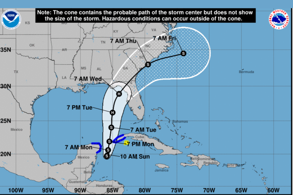
According to the National Hurricane Center's 11 AM Advisory on Sunday, August 27, 2023 Idalia is forecast to become a hurricane over the eastern Gulf of Mexico, and there is an increasing risk of life-threatening storm surge, flooding from heavy rainfall, and hurricane-force winds along portions of the west coast of Florida and the Florida Panhandle beginning as early as Tuesday.
Although it is too soon to specify the exact location and magnitude of these impacts, residents in these areas should monitor updates to the forecast, have their hurricane plan in place, and follow any advice given by local officials. Storm surge and hurricane watches may be required for portions of the Gulf coast of Florida later today.
Potential Impacts to Georgia
Will Lanxton, Meteorologist with the Georgia Emergency Management Agency (GEMA) issued this projection Sunday morning.
Tropical storm force and potentially hurricane-force winds are forecast to move into southern Georgia on Wednesday morning and afternoon. Downed trees and power lines are likely, especially closer to the center of the storm, producing widespread power outages across South and Central Georgia. As the storm takes a turn to the northeast, the strongest winds and heaviest rainfall will shift into eastern Georgia. Much of southern and eastern Georgia could receive 4 to 6 inches of rainfall from this system. While this could produce some isolated flooding issues, widespread flooding is not currently expected due to below-normal recent rainfall. A few brief tornadoes will also be possible near and east of the center of the track. Storm surge along the Georgia coast is expected to be low, but higher than normal water levels will be common.
Please monitor all forecast updates from the National Hurricane Center (hurricanes.gov), your local National Weather Service office (weather.gov), and reliable media outlets over the next few days as this system approaches the Gulf Coast. There is still a good bit of uncertainty in both the track and intensity forecasts, so shifts in future forecast packages could greatly affect the expected impacts to Georgia.
Follow and Subscribe to Grice Connect Now
Grice Connect is committed to being here for you providing you the important news you need, when you need it.
Now is the time to be thinking about your Hurricane preparation plans which include liking and following Grice Connect on Facebook and subscribing to Grice Connect daily emails so you can keep up with how this storm could impact Statesboro and Bulloch County.

For more hyper-local Statesboro, Georgia Southern, and Bulloch County news and events delivered directly to your inbox every day, subscribe to Grice Connect's Bulloch Daily email by clicking here. Totally FREE and ALL LOCAL! Unsubscribe at anytime.


